SIGHTS

Lake of Agios Nikolaos


The lake of Agios Nikolaos or lake Voulismeni is a small - formerly sweet, later connected to the sea, lake, located in the center of Agios Nikolaos in Crete. Its diameter is 137 meters and a depth of 64. Locals refer to it simply as the lagoon "pool". The lake is connected to the city port with a canal opened in 1870. Panoramic lake view offered by the park which is above it.

According to legend, the goddess Athena bathed in it.
It is reported that members of the German army during the retreat from the area during the Second World War, threw part of the arms and / or their vehicles in the lake.

Local urban legend says that the lake has no bottom. This view is probably based on the depth disproportionate in relation to the surface and / or disturbance to the surface or the water level of the residents observed during the earthquake of Santorini in 1956.

For this reason allegedly is geological relationship between the two positions, but academic research on the matter is not yet known.

Chrissi or Gaidouronisi (donkey) island.


One of the 81 uninhabited islands of Crete is Chrissi or Gaidouronisi (donkey) island.
Chrissi lies 8 miles away from Ierapetra's coasts, in the Libyan sea.

Chrissi is almost flat with colorful volcanic rocks covered in gold sand, purple shells and sand dunes.
On the west part of the island the visitor can see the well-preserved old chapel of Agios Nikolaos (possibly built in the 13th century), the salt pan which still gathers salt, the old port, the Minoan ruins, some Roman carved graves and the light house.

From mid-May until the end of October there are daily itineraries of vessels from the port of Ierapetra, 10.30 (phone 2842022294 Ierapetra Port Authority). After traveling approximately one hour, is picking up in the southern part of the island to "Vougiou Eye" next to the municipal tavern. From the landing area there is a path that leads visitors to the north of the island in the Bay of Belegrinas.
Visitors have approximately 6 hours to wander the endless beaches, enjoy turquoise waters, visit the church of St. Nicholas and let this unique ecosystem will steal the heart and make him daydream.

Islet of Spinalonga


Spinalonga, or Calydona as its official name is, is an islet almost closing the bay of Elounda; in antiquity there was a fort there, constructed by the Olounites. The actual name is Italian and means “long spine”; from here comes the former name of the island, called Makrakanthi for some period of time.

After Constatinopolis was conquered by the Francs of the 4 th Crusade, in 1204, Spinalonga, along with the rest of Crete was given to Bonifatius of Monferrat; this latter sold the island to the Venetians who took possession of the island in 1211 and kept it until 1715. The Venetians fortified the islet during 1571-1574.

The fort was very strong and had storerooms, water tanks and several buildings. Venetians kept possessing it, as it also happened with the forts of Gramvousa and Souda, even after the conquest of Crete by the Ottomans in 1669. During this period, Spinalonga was a safe refuge for the Greek population persecuted by the Ottomans.
In 1715, following the Treaty between Ottomans and Venetians, the islet passed to the Ottoman domination and, during the last years of it, was considered as a safe place of residence for Ottoman families.

When Crete was declared autonomous in 1898, the Cretan State converted it to leper house, initially only of Crete and later of entire Greece. Before the World War II, the islet housed more than 300 people suffering from leprosy, within the hospital of Aghios Panteleimon. The hospital stopped working and the islet totally abandoned in the 1960s’.

Near the fortress the visitor may see the three-aisled Basilica of Aghios Panteleimon, celebrated on the 27th of July.
Recently, several restoration works have been done to some of the buildings by the 13th Ephorate of Byzantine monuments.
Access to the islet is possible in summer by excursion boats departing from Agios Nicolaos, Elounda and Plaka.

The Palm Forest of Vai

The visit of Vai is something imposed on visitors to Crete. Combining the magnificent beach with the rare palm forest give an exotic touch.
According to a legend, Arab pirates who came to Crete threw out the pips of the dates they were eating while they were here and that from these came this grove of 5000 palms.
It is prohibited to camp overnight within the grove, which covers an area of 60 acres and is protected by fencing under the care of the Forestry Service. It is organised and has been awarded with the EU Blue Flag.

It is an exotic, tropical beach with fine sand and pebbles and crystal-clear blue sea, 6 km far from Palekastro. 24 km από τη Siteia and 65 km from St Nikolas..

Lassithi Plateau


Located at an altitude of 850 meters above sea level. Surrounded by high peaks, the tallest of which is the Sabre at an altitude 2148 meters above sea level. These peaks were protecting the inhabitants of the plateau from attacks.

There are two entrances to the plateau. One is from the side of St. Nicholas and the other from Heraklion by Kera. Over Seli Vine at an altitude of 900 meters are abandoned windmills. These mills and flour mills, made most of the Venetians, and the Peloponnese settlers late last century, to water of the plateau.

If you are in the area worth visiting the monastery of Crystal, built at an altitude of 850 m, the amazing gorge Havgas, the Lini, drainage canals, built by the Venetians, and the Diktaion Cave. The cave where according to mythology, Zeus was born. Around the plateau has a total of 21 villages, which are linked by a 23km road. The larger is the Tzermiado, the provincial capital, very close to the village is the cave of the Bank, with stalactites, stalagmites and Neolithic relics.

The Gorge of the Deads from Zakros to Kato Zakros


The entrance of the gorge of Zakros is found just off the village of (Epano) Zakros at a distance of 99 kilometers far from Aghios Nicolaos at the Southeast and 35 kilometers Southeastern to Sitia. It is a very beautiful gorge with high walls, full of caves. Many of these caves are archaeological sites, as a lot of important Minoan burials have been found there, which have also gave to the gorge its name “gorge of the deads”. After some two hours of walking within a fascinating environment you will arrive at the exit of the gorge close to the Minoan palace of Kato Zakros.

One of the advantages of this gorge is that the visitor has not to walk back in order to pick up the car or the motorbike, as buses are available from Kato Zakros to Zakros. Several works of reformation are being done in the area, in order to facilitate the visitors of the place; as a result, a lot of people, mainly foreign tourists, visit it every year.

Access to the gorge from Aghios Nicolaos or Sitia is possible by rented or private car and motorbikes. You will leave your car at Epano Zakros, walk down the gorge and then catch the public bus from Kato Zakros and return to pick your car up.

Psychro Cave


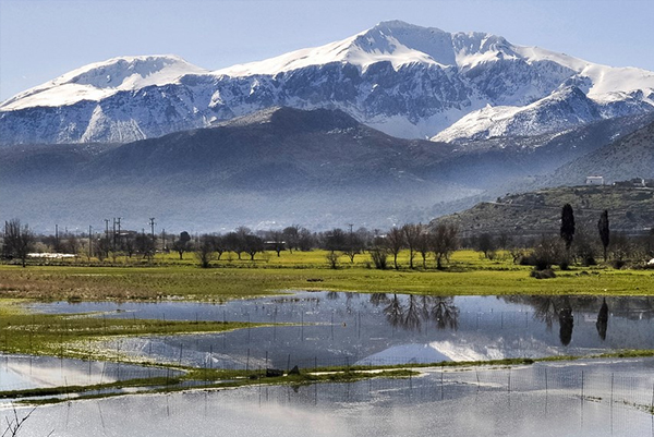
The Cave of Psychro is situated at the Lassithi plateau, some 65 kilometers far from Aghios Nicolaos at the West, 16 kilometers southwestern to the village of Germiado and approximately 1 kilometer far from the homonymous village at the Southwest.

It used to be one of the most important ritual places of Minoan period. Worship in the cave seems to have started to practice in the Early Minoan period (2800-2300 b.C.), although there are traces of human activity in the cave even earlier. The most important finds are dated to the Middle Minoan period (1800 b.C.) and to more recent periods up to the Geometric (800-700 b.C.) and Archaic (700-500 b.C.) periods . It is likely that the cave was used even during the Roman times. Numerous finds have been brought to light as votive offerings (human figures and statuettes of gods and animals), double axes, arms, tools and other items.

Some scholars suggested that the cave of Psychro is the well-known Diktaeon Andron that, according to Greek Mythology, was the place where Zeus, the king of gods was born and bred up. It is here that the divine goat Amaltheia gave him its milk and the Couretes looked after him. The cave is also linked with the myth of Zeus and Europe and with the soothsayer Epimenides who is said to have passed away in this cave.

The cave was excavated for the first time by the Greek archaeologist Joseph Chantzidakis, in co-operation with Italian archaeologists at the end of the 19 th century. The works continued later by several archaeologists, but excavations were never conducted in a systematic way. Most of the finds come from illegal excavations and are housed in the Museums of Heraklion and Oxford.

The cave is found at a height of more than 1.000 meters and access to it is possible via an uphill path, starting from the public road. After the narrow entrance there is a hall (42 X 19 meters), where there was a rectangular stone shrine. Neolithic potsherds, Early Minoan burials and Middle Minoan votive offerings were found in this hall. At the very northern edge it has been excavated an enclosure with stone paved floor, occasionally preserved today; the construction seems to be a “temenos”.

Successive to the first hall there is another, bigger one (84 X 38 meters), sloping downwards, with a small chamber at its left edge, the so-called “cradle of Zeus”.
At the right, a bigger chamber (25 X 12 meters) is divided in two parts, one with a small lake and the other with an impressive stalactite, poetically called “the Mantle of Zeus”. A good number of votive offerings, mainly bronze statuettes, knives, spearheads and double axes have been found here.

Access from Aghios Nicolaos is possible only by rented or private cars and motorbikes.

Kritsa


Kritsa is located 11 km inland from the large town of Agios Nikolaos in the East of Crete. Kritsa is a traditional village with old houses and narrow streets on the Lassithi (Dikti) mountains.
As you approach you can see Kritsa nestling in a bowl at the foot of the Dikti Mountains, under a red overhang of rock known as Kastellos.

From many vantage points throughout the village there are far reaching views across the olive groves that produce delicious award-winning oil, down to the coast and up to the rounded Thripti Mountains that spectacularly fill the eastern view.

If you intend to visit our famous church, Panagia Kera to see the wonderful frescos painted in Byzantine times, you need to know that it the church isbefore you reach Kritsa: after passing the village of Mardati, look out for a restaurant called Paradise, (about 1k before Kritsa) the parking area on the right hand side of the road is for the church.

Another place to visit on the way to or from Kritsa is the well-preserved ancient Dorian City of Lato; it is a hidden hill top gem just 3k away. Lato is one of the most fully preserved cities in Greece and is apparently the best example of the Classical-Hellenistic period in Crete.
Both Panagia Kera and Lato are open daily 8.00 a.m. to 3.00 p.m. except Monday

Kroustas

As you drive through Kritsa there is a sign on the left for the village of Kroustas. The village of Kroustas is 11km southwest of Agios Nikolaos on the Agios Nikolaos - Kritsa - Kroustas road

It has a spectacular view of the Mirabello Bay and the peaks of Mount Thripti

It is a more typical village than Kritsa and contains the beautiful Byzantine church of Agios Ioannis Theologos